GEOPOLITICA
What the Plauru incident reveals about the gaps in radar coverage on the Danube border
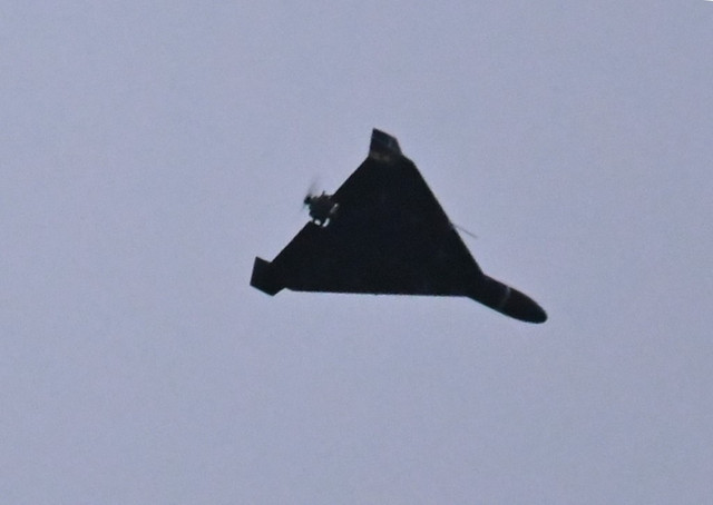
An object, possibly an aerial drone, fell at around 5:00 a.m. during the night of October 1–2, 2026, in the area of the locality of Plauru in Tulcea County, causing a fire, according to MApN.
The stakes go beyond a fire extinguished within a few hours. MApN specified that radar systems did not report any unauthorized penetration of national airspace during the night, even though the object ended up on Romanian territory during a drone attack on targets in Ukraine, near the river border. The verifiable thesis of this article: the Plauru incident indicates an insufficient radar coverage zone at low altitudes along the Danube border, and the dominant scenario — a technical investigation followed by strengthened detection — has a probability in the 30–45% range, with the caveat that identifying the nature of the object could completely change the interpretation.
1. What happened, according to the MApN statement
The Ministry of National Defence reported on Friday morning that during the night of October 1–2, the radar surveillance system detected new drone attacks on civilian and infrastructure targets in Ukraine, in the northern area of Tulcea County, in the proximity of the river border with Romania. In other words, the military saw the attack — but not the object that subsequently ended up in Romania.
At around 5:00 a.m., the fall of an object, possibly an aerial drone, was reported in the area of the locality of Plauru, followed by the outbreak of a fire. According to MApN, the fire caused no casualties and no material damage was recorded. An IGSU fire truck and MApN teams were dispatched to the scene for extinguishing.
The area was secured, and specialized teams from the ministry are to conduct an on-site investigation to determine the nature of the object and the circumstances of the fall. Until these investigations are completed, the object's status remains "possible drone" — the official wording in all the statements cited here, not a confirmed technical conclusion.
The ministry's central clarification, repeated identically in the sources in this cluster, is that the radar systems did not report any unauthorized penetration. The two statements — "the radars saw the attack on Ukraine" and "the radars did not see the penetration into Romania" — do not contradict each other, but together they describe a coverage limit that is the subject of the analysis below.
2. The mechanism: why a drone can go undetected
The causal chain, step by step
The first step of the causal chain is the intensity of Russian attacks on Ukrainian infrastructure in the south of the country, near the Danube. On the night of the incident, Romanian radar detected these attacks, according to the MApN statement cited by HotNews. When attack drones fly toward targets a few kilometers from the border, the probability that some will deviate, be damaged, or crash across the border increases mechanically with the number of launches.
The second step is the physics of detection. Air surveillance radars are built to cover mainly medium and high altitudes, where conventional aircraft fly. A Shahed-type drone, with a relatively small fuselage and low-altitude flight, presents a small radar cross-section and can be lost in the background noise generated by floodplain terrain, vegetation, and ground-level reflections — the technical phenomenon known as clutter.
The third step is the geometry of the Danube. The river border allows a drone following the river's course to remain at very low altitude, sometimes below the direct line of sight of a radar located at a distance. An object flying a few dozen meters above the water and reeds can be "hidden" by the radar horizon even at short distances.
The final effect of the chain: a damaged or deviated object can enter Romanian airspace, crash, and cause a fire without any surveillance system generating an alert. The fall was reported from the ground — at around 5:00 a.m., according to the statement — not by radar.
Counter-hypothesis: the object did not cross controlled airspace
There is an alternative explanation that must be weighed seriously. It is possible that the object never crossed, in the technical sense, the airspace that radars effectively monitor at low altitudes — either because it came on a trajectory that bypasses the covered sectors, or because it was a remnant of a drone intercepted by Ukrainian air defense, whose fall trajectory is no longer a controlled flight.
This counter-hypothesis is plausible and cannot be excluded with the available data. The difference from the main thesis is subtle but important: the former describes a coverage gap that Romania can correct with equipment and procedures, the latter describes a partially inevitable phenomenon in the vicinity of a war, which no radar network can completely eliminate. The data published as of Friday morning are not sufficient to demonstrate which of the two dominates; the on-site investigation and trajectory analysis are the only instruments that can arbitrate between them.
One element supporting the coverage-gap thesis is the repetition of the situation. According to SpotMedia, on Tuesday — that is, September 29, 2026 — a drone carrying an explosive payload fell in the Great Island of Brăila, and MApN specified at the time, likewise, that radars did not detect an unauthorized penetration. This information about the Brăila incident comes from a single source in the cluster and has not been independently verified by this publication; the exact status of radar detection in that case remains unverified.
Two falls in the same week, both undetected by radar, suggest a systemic low-altitude coverage problem, not an isolated accident. However, a sample of two events is not sufficient to demonstrate a statistical trend — it is only sufficient to elevate it to the rank of a legitimate working hypothesis.
3. The actors: who decides and who responds
The first actor is MApN, as the operator of the radar surveillance system and the author of the public statements. The ministry acted ex officio: it sent teams to the scene, secured the area, and announced specialized investigations to determine the nature of the object. The statement does not specify the legal classification of the incident, the exact nature of the object, or the reconstructed trajectory — these are, as of publication, publicly unknown.
The second actor is the Inspectorate for Emergency Situations, which intervened with a fire truck to extinguish the fire. The IGSU's role is immediate operational response, not investigation; the separation of the two roles matters because the results of the MApN investigation, not the extinguishing report, will establish what happened. The third actor is, indirectly, NATO.
The reference to Article 4 consultations must be read here as a possibility of institutional escalation, not as a precedent already activated for the Plauru incident — no statement in the cluster mentions such a consultation in this case. The fourth actor is Russia, as the author of the drone attacks on Ukrainian infrastructure near the border.
A strict separation must be made here between capability and intent: the fact that Russian drones strike targets at the border is documented by Romanian radar detections; the fact that an object fell in Romania does not demonstrate, at this stage, a deliberate targeting of Romanian territory. The available sources do not allow intent to be established.
Finally, the most exposed actor is the population of the border localities in northern Tulcea — villages such as Plauru, located directly on the line of contact between the war in Ukraine and NATO territory. For these communities, the difference between "the radar saw the object" and "the radar did not see it" translates into minutes of warning in the case of an object that does not fall in an empty field.
4. What we cannot yet know and why it matters
The first unknown is the nature of the object. The statements consistently use the wording "possibly an aerial drone," which means the on-site investigation had not been completed at the time of publication. If the object turns out to be a Russian attack drone, the incident enters a different diplomatic category than the case of a remnant of a Ukrainian interception.
The second unknown is the trajectory. Without a reconstruction of the trajectory — which requires radar data from multiple sources, including possibly allies — it cannot be established whether the object flew over Romanian territory for a significant distance or fell immediately after crossing the river. The trajectory determines whether the gap is one of detection or merely of alerting.
The third unknown is the actual moment of entry into airspace. The radar saw the attack on Ukraine, but not the penetration into Romania; between the two events there may be an interval of minutes or seconds, and this interval is exactly what defines the reaction time available for measures to protect the population.
These unknowns are not procedural details. They separate an incident that can be managed with securing procedures from an incident that would require doctrine changes, additional procurement, and allied consultations. Until the investigation results, any categorical statement about what happened would exceed the available evidence.
5. Scenarios for the coming period
Dominant scenario: technical investigation and strengthened detection
The dominant scenario, with an estimated probability in the 30–45% range, is one in which MApN completes the investigation, confirms the drone nature of the object, does not activate additional NATO mechanisms, and announces in the coming weeks measures to strengthen surveillance in the Danube area. The engine of the scenario is the public pressure generated by the repetition of undetected incidents; the constraint is the defense budget and delivery times for equipment. Indicator to watch: MApN statements and possible announcements regarding drone detection or counter-drone systems on the Danube flank.
Plausible scenario: recurring undetected incidents
A plausible scenario, with an estimated probability of about one-third, is the continuation of attacks on southern Ukraine and the repetition of undetected falls on Romanian territory. Here the mechanism is purely statistical: the more drones are launched toward targets at the border, the more deviations and falls. The constraint is that Romania does not control the intensity of Russian attacks. Indicator: the number of MApN statements combining "fall on national territory" with "radars did not report penetration" over the course of a month.
Tail scenario: diplomatic escalation and NATO
A tail scenario, under one in four, involves a fall with casualties or significant material damage, which would activate NATO-format consultations and a broad diplomatic reaction. The engine would be domestic and allied political pressure; the constraint, the allies' reluctance to escalate in the absence of demonstrated deliberate targeting. Indicator: the official convening of ambassador-level consultations, publicly announced by Alliance headquarters.
Improbable scenario: public dormancy
An improbable scenario is one in which the incident generates no visible change in public policy and disappears from the media agenda. Its probability is estimated at under one in ten, precisely because the rapid repetition of incidents makes them difficult to ignore. Indicator that would confirm it: the absence of any publicly announced measure for more than a month after the incident.
6. Verifiable predictions
| Prediction | Horizon | Probability | How to verify | Verification source |
|---|---|---|---|---|
| MApN publishes the results of the investigation into the nature of the object that fell at Plauru | 31.10.2026 | 50–70% | official statement confirming or denying drone status | mapn.ro, statements section |
| At least one new incident of an object falling on Romanian territory in the context of attacks on southern Ukraine | 31.12.2026 | 40–60% | MApN statement with date and locality | mapn.ro, press statements |
| MApN or the Government publicly announces measures to strengthen drone detection/counteraction on the Danube flank | 31.03.2027 | 30–45% | official announcement of procurement, deployment, or procedural change | mapn.ro and Government statements |
| NATO consultations formally invoked by Romania in connection with the Danube incidents | 31.12.2026 | 10–25% | public announcement of the convening of Article 4 | nato.int, Alliance press statements |
| A Danube incident produces casualties or significant material damage | 31.12.2026 | 10–20% | MApN or IGSU statement with a casualty toll | mapn.ro, igsu.ro |
Method, definitions, and figures
All primary facts of this article come from the MApN statement relayed by the press in the cluster: G4Media, SpotMedia, Antena 3 CNN, HotNews, Biziday, and Mediafax, all published on the morning of October 2, 2026. No figures from outside these sources were used; where information comes from a single source — the case of the Great Island of Brăila incident — this is explicitly noted in the text. Definitions.
"MApN's radar surveillance system" designates the network of radars of the Ministry of Defence, with its actual coverage perimeter and performance, which are not public in detail. "Unauthorized penetration of national airspace" is the official wording from the statements; it refers to the detection of an unauthorized flight, not the fall of an object, and the difference between the two notions is precisely the subject of the analysis. Derivations.
We did not calculate rates, averages, or derived shares, because the available sources do not offer numerical data series — only a time of day (5:00 a.m.), a date (the night of October 1–2, 2026), and official qualifiers (no casualties, no material damage). Day-of-week verification: October 2, 2026 is a Friday, so "Friday morning" in the statements is coherent, and "Tuesday" for the previous incident corresponds to September 29, 2026.
The probabilities in the scenarios and in the prediction table are editorial intervals calibrated manually, not outputs of a statistical model. Non-comparabilities. MApN statements for different incidents are not directly comparable with each other: the wording "radars did not report unauthorized penetration" can cover different technical situations (non-detection, uncertain detection, an object that did not generate a track). The press in the cluster reproduces the statement, not the primary radar data, which are not public.
Limitations of the analysis
This analysis cannot establish the nature of the object that fell at Plauru, its trajectory, or the intent of the launcher's author, because MApN's on-site investigation had not been completed at the time of publication, and the primary radar data are not public. The claim of a low-altitude radar coverage gap is a working hypothesis supported by two consecutive incidents, not a demonstrated conclusion; an alternative explanation — remnants of a Ukrainian interception with an uncontrolled trajectory — remains equally plausible on the basis of the available evidence.
Data are visibly missing at three points: the total number of drones launched on the night of the incident, the distance traveled by the object over Romanian territory, and the technical details of radar coverage in the northern area of Tulcea. The information about the Great Island of Brăila incident depends on a single source in the cluster and has not been independently verified.
The diagnosis would be invalidated if MApN's investigation established that the object was not a Russian attack drone, that it was detected by allied systems without the information being published, or that it entered Romania on a trajectory that any real radar network would have been incapable of seeing. An update is necessary immediately after the publication of the results of the on-site investigation and, in any case, after the next Danube incident, which would transform the sample of two events into an analyzable series.